Highland Score
The inclusion of the Highland sub-corridor in Project Connect’s (PC) initial recommendation to the Central Corridor Advisory Group (CCAG) made me curious about it.
After examining the released data and documentation, it is clear that Highland’s score is the result of speculative assumptions about the nature of development in the sub-corridor. This has implications both for CCAG and Council as they debate which sub-corridors are worthy of further study.
Now let’s turn to the data.
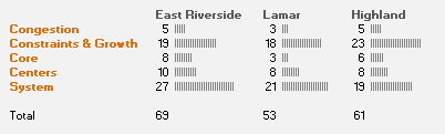
For those not closely following the PC recommendation, it utilized a set of synthesized indices to differentiate the sub-corridors. The main index had a set of 'problems' it covered and each sub-corridor got a set of points for that problem. As the chart above illustrates, Highland got the bulk of its problem-level points in two problem areas: (1) ‘Constraints & Growth’ and (2) ‘System’.
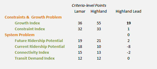
If we delve into these and examine the criteria-level scoring, we find that Highland accumulated its criteria-level points lead over Lamar in just one index.
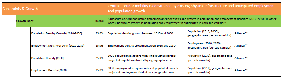
So, what exactly is in the Growth Index? It is outlined below in a screenshot from the released PC documents.
The use of both population and employment density growth projections is problematic. It is unclear from the released documentation if the PC team scored either the rate ("32% growth from the 2010 base") or the count ("1377 more people per square mile than in 2010") of density growth. Either way, this leads to points being scored by a metric that is tangential to transit success.
The actual density of population and employment is relevant as it is a proxy for demand. The rate of growth might be relevant as a way of anticipating future growth past 2030. But that is such a noisy projection (it’s actually projection built on top of a projection based on a subjectively compiled allocation of growth!) that it is not useful in this type of decision-making. If we exclude the problematic density growth estimates, the chart below reveals what the sub-corridor density data looks like.
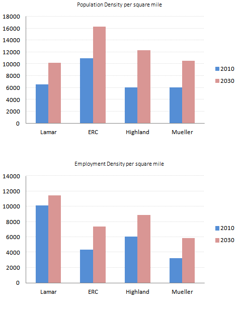 Remember that the Project Connect staff chose to remove West Campus from the Lamar sub-corridor as a way of indicating that ‘the University would be served as part of the Core’. That choice, however, obscures that a real-world Lamar alignment would serve high density West Campus. Even with that suspicion-arousing omission, Lamar is still presently competitive with both Highland and Mueller on population density and dominates on employment density.
It turns out that the estimate of the 2030 population density is where Highland really earns its points both because of the expected growth in density and the double-counting-like nature of the growth rate points criticized above. So, why does Highland grow so quickly? Well, this is where things get interesting and quite murky.
The demographic allocation methodology begins by looking at the expected CAMPO growth totals across the region's counties for 2035 and then allocates it across Austin parcels. Each parcel in the study area is rated on ‘attractiveness’ and placed into a bin of similarly attractive parcels. The precise methodology for the attractiveness calculation is not fully clear as the released explanatory document for the first attractiveness algorithm - there's a second one subsequent to this one - has some quirky notes in it:
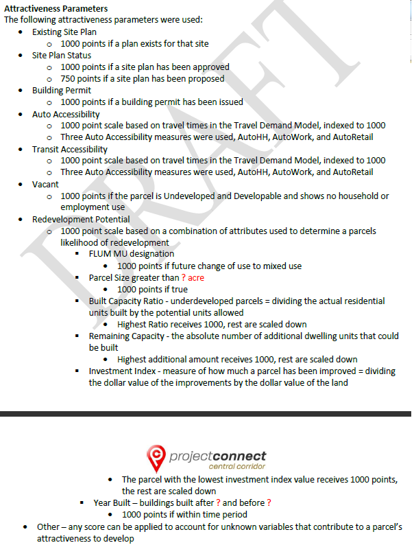
The total growth from CAMPO projections was then divided into the bins and subsequently allocated to the parcels. The parcels in each bin received growth up to their capacity until the growth increment in the bin was depleted. ‘Capacity’ for 2030 – and this is absolutely key - was determined by the likely maximum household count for the parcel as a result of the rules below:
 For those not familiar with the zoning jargon, 'FLUM' stands for 'Future Land Use Map'; 'UPA' means 'units per acre'; MU means 'mixed use'.
That ‘likely maximum’ household count was then multiplied by a household size coefficient that gets smaller as the units per acre increase. For example, a household on a parcel with 45 and over units per acre is expected to have a household size of 1.6. A household on a parcel with 4 or less units per acre is expected to have a household size of 3.
The bottom-line is that the methodology awards points to larger parcels that are relatively undeveloped and (seemingly?) car-dependent based on an optimistic outlook on future land-use entitlements being granted. It is not a prediction of how parcels will behave in the future given what similarly-zoned parcels have done in the past. It is not a sophisticated statistical model of what is likely to be that uses historical data to forecast. Instead, it is scoring based on where the methodology-designers would like development to go that uses a proven statistical technique to classify the parcels into different bins based on parcel attributes. The methodology has not been validated, so we don't know if it actually predicts anything.
The public reasoning presented to CCAG by the PC team for Highland’s score is ‘significant future development’. Obviously, projects such as the ACC Highland Mall redevelopment and Austin’s evolving medical scene will have an impact on employment and residential density in the sub-corridor. But it also appears that the methodology selected assigns significant points to the type of parcels available in the sub-corridor. Needless to say, the presence of certain types of parcels we’d like to see developed in a sub-corridor does not mean development will happen. Worse, it doesn’t mean they exist in a contiguous stretch that make sense for a transit route.
The growth index issues are all compounded by the use of a 2030 endpoint. A long-term end point makes total sense when we write the FTA New Starts application as it will allow us to put down the largest trip and Vehicle Miles Traveled numbers given our continued growth in the future. The goal in the New Starts application is to put forth the best argument for the selected route.
But when contemplating the actual route selection, we should prioritize the likelihood of success instead of prematurely engaging in gaming of the FTA New Starts application. Leaning on observable data about development and known patterns about transit ridership is a more solid foundation for successful route selection than a scaffold of rushed projections.
Given Highland's questionable value, short-term actions for policymakers are clear. Further discussion of Lamar should restore West Campus within its boundaries. I don't personally care if they put it on the official map as long as policymakers get an 'alternative' map that includes it. Hopefully, Lamar will continue to be evaluated in the next phase of study. Additionally, more detailed and intelligible documentation around the demographic allocation tool should be released. Both CCAG and Council should begin to scrub the evaluation methodology for high-noise/low-value elements such as the density growth rate elements. Finally, Council needs to examine what land-use policy in the Highland corridor would actually be needed to actually meet the speculative ‘maximum capacity’ future implied by the demographic allocation methodology.